How does the captain Receive HiFleet's Voyage Weather Forecast Email?
This service has been available for over a year and has been well received by captains. More than 7,000 weather forecast emails are sent weekly.
1. Add a Planned Route
- Navigate to the "Future" section on the "Map" page, select the target vessel, and enter the "Future" page. There are four ways to add a planned route:

- Hand-Drawn Route: Set turning points on the chart. Right-click to finish, enter a name, and save as a navigation plan. The system will automatically designate it as the execution route.
- Route File Upload: This feature supports multiple formats, including xls, csv, xml, rux, rx4, and rtz. Route templates are available for vessels with unsupported formats or without electronic charts.
- Voyage Planning: Select the starting point (current location) and ending point (ETA location from AIS) on the map, then click "Draw" to create the route. Save as "Planned Route" to view in the plan list.
- Email Registration: Click the "Email" button, set an email address, and save. When the master or maritime personnel email the planned route (exported from ECDIS) to the company, they should also send it to reports@hifleet.com for automatic uploading to your HiFleet account.
2. Start Sending Voyage Weather Forecast Emails:
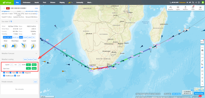
- Sending Method: After drawing/uploading/importing the planned route, go to the vessel's "Current" page in the "Weather Routing" section. Click the [Mail] button, set the receiving email address, and confirm to start sending.You can set the planned departure time and the planned voyage speed also here.
- Sending Schedule: Emails are automatically sent every 6 hours after the vessel sails (00:00 / 06:00 / 12:00 / 18:00). By default, one email is sent daily.
3. Email Settings:
- The received voyage weather forecast email includes options to set planned speed, sending frequency, and unsubscribe settings. Simply click the link to adjust settings or reply directly to the email.
- For example, reply with the desired speed, such as "12.5," or adjust frequency by replying "D1" (once a day) or "D4" (four times a day). To unsubscribe, reply with "unsubscribe."

The meteorological factors of the navigation position and time in the next 5 days and the speed estimation are as follows:


The calculated position and weather map are as follows:
If you have any questions, please contact us:
Email:Support@hifleet.com
Wechat:+86 152 7081 6985
How does the captain use the HIFLEET route optimization?
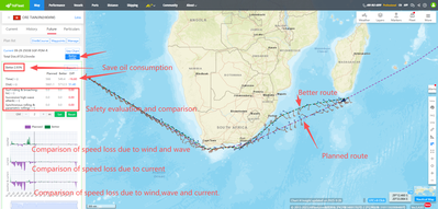
Approximately 15 minutes after the user uploads the planned ship route, they can view the "Better Route" (if available) under "Ship - Plan - Executed." If no better route is displayed, it indicates the system has not identified any optimization for the current route. Clicking "Beeter Route" allows users to compare the economic and safety parameters between the better route and the current planned route.
If the user wishes to utilize the better route, they can "export" the waypoints and send it to the vessel for updating the planned route on the electronic chart.
Precautions:
1.Before using the optimized route, the captain must conduct a safety check on the electronic chart and make minor adjustments if necessary.
2. Since marine weather forecasts may undergo significant changes in the future, it's essential to check daily for any newly optimized routes.


